HUGEROCK / T71 PLATFORM

G71GNSS / RTK & GIS Capture Handheld

For surveying and GIS software providers, location-service integrators and inspection partners. Select G71N, G71F or G71M receiver configurations around accuracy, correction sources and output protocols.

7″4G10000mAhIP67Application-specific configurations
01 / APPLICATION FIT

Professional GNSS / RTK & GIS capture

Specify meter-level or RTK tasks, correction service, coordinate system, data format and mounting. Review receiver and antenna together and validate under actual obstructions.

01 / FIELD WORKFLOW

GIS & geospatial data capture

02 / FIELD WORKFLOW

Utility & pipeline inspection

03 / FIELD WORKFLOW

Surveying & land management

Professional GNSS / RTK & GIS capture

Specify meter-level or RTK tasks, correction service, coordinate system, data format and mounting. Review receiver and antenna together and validate under actual obstructions.

Share deployment countries, business software, site environment, peripherals, mounting, sample plans and expected volume to review software, hardware and delivery configuration.

02 / ONE PLATFORM, APPLICATION BRANCHES

One platform. Select for the application.

Compare display, storage, capture and positioning requirements. Ex certification and specialist modules are specific to the branch and ordered configuration.

T71 product view7-inch rugged field platform

T71

A 7-inch rugged platform for industry software providers, system integrators and device brands. Select industrial, outdoor, hazardous-area, precision positioning or data capture configurations around your deployment.

Explore configuration & specifications ↗
T71L product view6GB / 64GB industrial configuration

T71L

For work orders, equipment inspection and industry applications, with 6GB / 64GB and a choice of 1000-nit or 2200-nit displays for site lighting.

Explore configuration & specifications ↗
X71 product viewOutdoor navigation & sunlight visibility

X71

An outdoor market product based on T71, with a 7-inch 2200-nit display, 10000mAh battery and 4G for navigation, equipment integration and mobile visibility.

Explore configuration & specifications ↗
T71EX product viewHazardous-area inspection & field mobility

T71EX

The hazardous-area branch of T71 for oil, gas and petrochemical inspection software providers, system integrators and equipment service partners. Match Ex marking, NFC and industry applications to the site.

Explore configuration & specifications ↗
G71 product viewProfessional GNSS / RTK & GIS capture

G71

For surveying and GIS software providers, location-service integrators and inspection partners. Select G71N, G71F or G71M receiver configurations around accuracy, correction sources and output protocols.

Explore configuration & specifications ↗
R71 product viewNFC capture & asset management

R71

The T71 data-capture branch for asset-management software providers, inspection integrators and industrial IoT partners. Link equipment, assets and work orders through NFC tag reading.

Explore configuration & specifications ↗

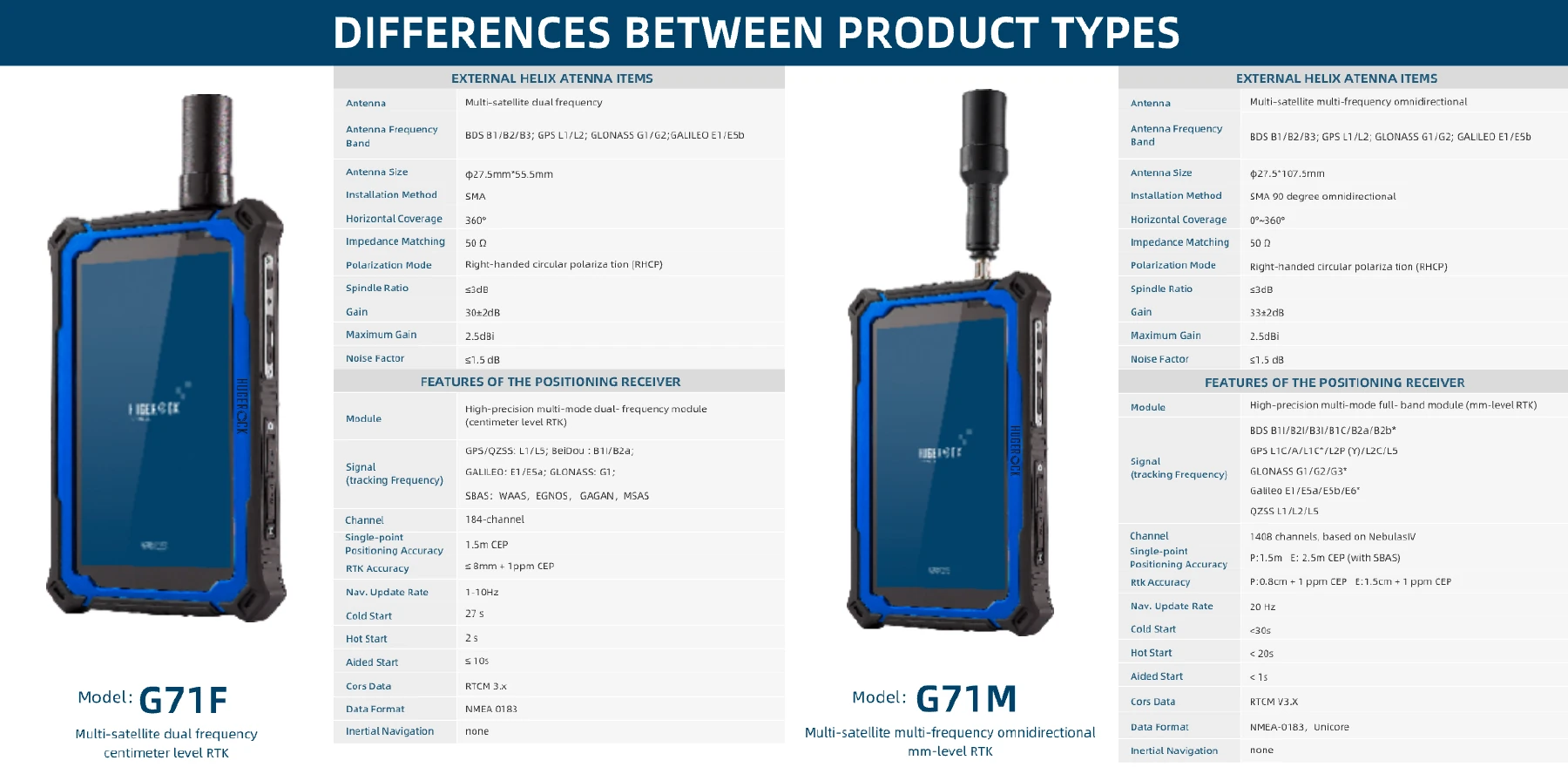
G71N offers meter-level RTD; G71F and G71M use different RTK receivers. Review the full model configuration for compatibility with existing G71L deployments.

03 / MODULES & INTEGRATION

Match modules, software and site conditions.

Select the required functions and protocols, then validate reading distance, corrections, interfaces, power and software on samples.

G71 receiver selection
CapabilityG71NG71FG71M
Receiver configurationMulti-mode single-frequency / meter-level RTDMulti-mode dual-frequency RTKMulti-mode full-band RTK / NebulasIV
Channels921841408
Single-point accuracy1.5m CEP (with SBAS); 2.0m CEP (without SBAS)1.5m CEPP: 1.5m / E: 2.5m CEP (with SBAS)
Differential accuracy1.5m CEP (with RTD)≤8mm + 1ppm CEPP: 0.8cm+1ppm CEP / E: 1.5cm+1ppm CEP
Update rate1–25Hz1–10Hz20Hz
CorrectionsRTCM 3.3RTCM 3.xRTCM V3.X
Data formatNMEA 4.10 / UBX binary / RTCM 3.3NMEA 0183NMEA-0183 / Unicore
Inertial navigationNoneNoneNone

Accuracy depends on corrections, satellite visibility, antenna and site conditions. Validate against receiver test conditions and project requirements.

04 / TECHNICAL SPECIFICATIONS

Review the specifications for your deployment.

Review this branch against the selected modules, OS version and accessories.

G71 device & environmental specifications
ProcessorARM Cortex A73 octa-core (2.0GHz)
GraphicsARM Mali-G72 MP3
RAM / storage8GB / 128GB
Display7″ FHD / 1080×1920 / 2200 nits
Battery10000mAh
Rear / front cameras13MP AF + flash / 5MP
TouchCapacitive / glove touch / spray / active capacitive pen
Expandable storagemicroSD, up to 1TB
SIM card1.8/3.3V standard SIM
Data interfaceUSB Type-C (OTG) ×1
ChargingType-C ×1 / 5.0V 2A, 10W
Headset3.5mm (CTIA)
PositioningSelect G71N / G71F / G71M receiver configuration
2G bandsGSM B2/3/5/8
3G bandsWCDMA B1/2/5/8
4G bandsTD-LTE B38/39/40/41; FDD-LTE B1/B2/B3/B4/B5/B7/B8/B12/B17/B20/B28
4G dataFDD / TDD: 150Mbps down / 50Mbps up
Wi-Fi2.4GHz / 5GHz; 802.11a/b/g/n/ac
Bluetooth5.0 LE
SensorsGravity / magnetic field / gyroscope / rotation vector / light / acceleration
OS versions & compatibilityAndroid 9 / 10 / 11 / 13
Dimensions202 × 131 × 21mm
Weight700g
Water / dust resistanceIP67 (IEC 60529)
Drop / impactMIL-STD-810G / touch panel IK05
Vibration1–19Hz / 1.0mm; 19–200Hz / 1.0g
Operating temperature-20°C to 55°C
Storage temperature-40°C to 80°C
Relative humidity5% to 95%
Altitude4,500m
ReliabilityMTBF >5000h / MTTR <0.5h
Certification3C / FCC / CE / ROHS / IP67
WarrantyDevice 24 months / battery 12 months
View full specification & module sheets +
05 / CONFIGURATION & DELIVERY

From configuration to deployment.

Work with product and engineering teams to validate business software, modules and operating conditions together.

Enquire about this configuration ↗

Choose the model and application to review OS, modules, accessories and delivery configuration.

01 / DEFINE

Define workflow & site

Deployment countries, application, visibility, site conditions and compliance scope.

02 / VALIDATE

Validate software & modules

OS versions, applications, tag samples or correction services, peripheral protocols, mounting and power.

03 / DEPLOY

Confirm configuration & delivery

Sample results, exact device model, accessories, volume and rollout schedule.

sales@soten.com.cn ↗

G71 selection & system integration

Assess G71 against accuracy targets, receiver configuration, antennas, corrections and output protocols. Distinguish GNSS, RTD and RTK configurations and validate application integration in the field.

For: GIS software providers, surveying teams and positioning integrators

Check model datasheets · Prepare SDK and application interfaces · Discuss your project configuration

Your next industrial innovation.
Starts with engineering.

Talk to SOTEN about your application, device configuration and system integration.

Contact SOTEN
YOUR PROJECT REQUIREMENTS

Prepare your project brief

Describe your application and integration requirements. Download the brief to your device and share it with SOTEN when you are ready.

IP Geolocation by DB-IP