 7-inch industrial smart terminal
K70
7-inch · compact installations & proximity reading
GK101M 10.1-inch RTK Positioning & Heading Terminal. Assess GK101M against accuracy targets, receiver configuration, antennas, corrections and output protocols. Distinguish GNSS, RTD and RTK configurations and validate application integration in the field.
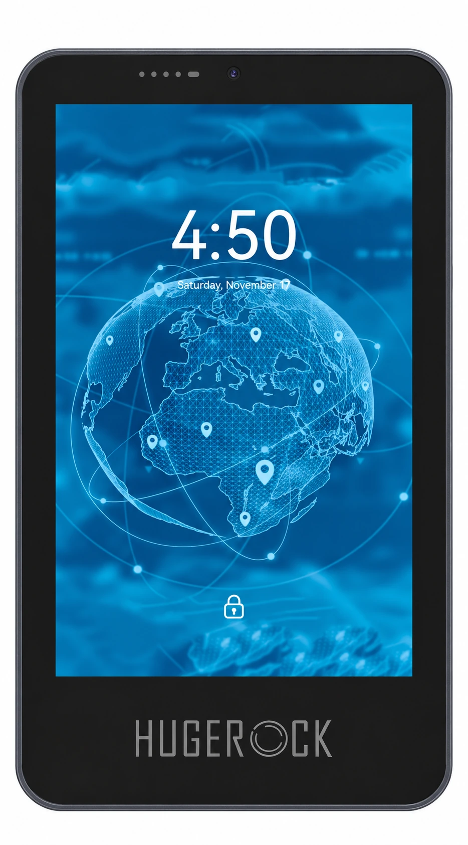 GK101M front view
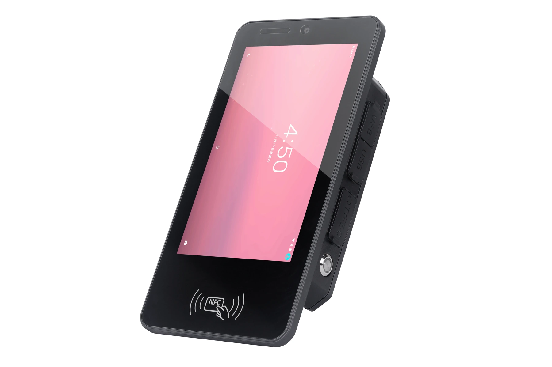
 GK101M rear & mounting
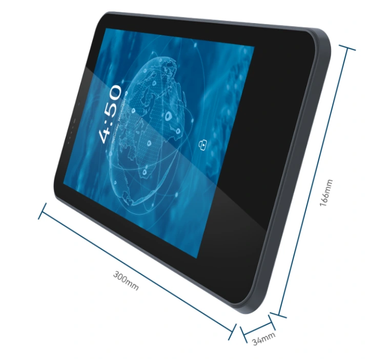 Device dimensions
 Vehicle interface diagram
 Antenna & card-slot diagram
 Receiver & antenna configuration
Product images · configuration varies by model · select an image to enlarge
Start with mounting space, power and display requirements, then review OS versions, software, peripheral protocols and modules. Optional functions depend on the delivered configuration.
Integrates UM982 dual-antenna RTK positioning and heading, a bright 10.1-inch display and vehicle interfaces for agricultural guidance, construction vehicle location services and equipment integration partners.
For agricultural guidance developers, construction fleet service providers and vehicle integrators bringing position, heading and operator interfaces into their software. Validate corrections, dual-antenna baseline, power and control-system integration. Autonomous driving and implement control are provided by the connected system.
Start with screen size and installation space, then compare brightness, storage, power, OS versions and workflow modules. Each model has its own configuration and environmental specifications.
7-inch industrial smart terminal7-inch · compact installations & proximity reading
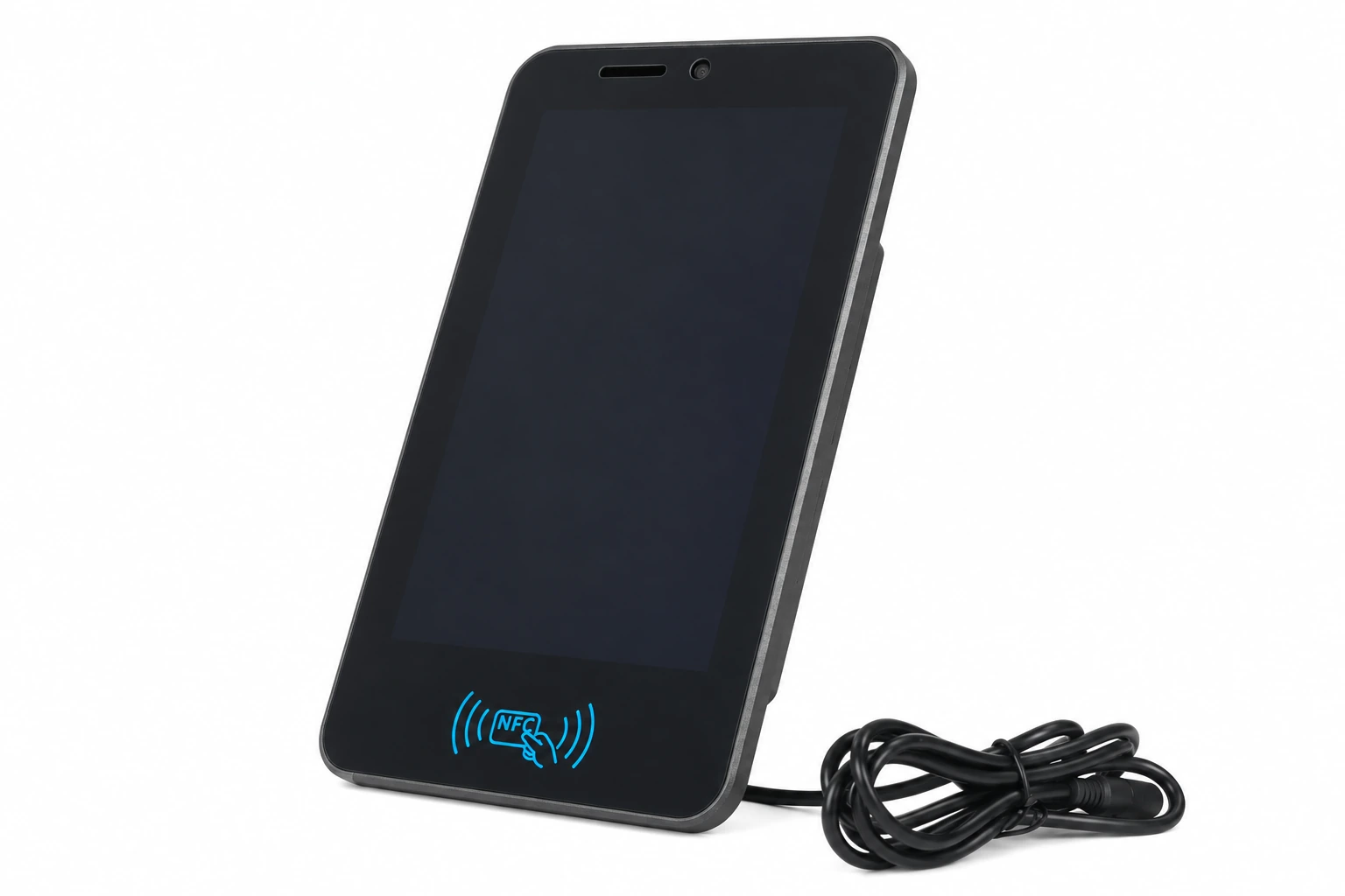 8-inch vehicle & fixed-mount terminal
8-inch · vehicle & equipment workstations
 10.1-inch industrial HMI terminal
10.1-inch · larger interfaces, positioning & heading
| Model | Screen / resolution | Brightness | RAM / storage | Power | OS versions | Workflow configuration |
|---|---|---|---|---|---|---|
| K70 ↗ | 7″ IPS/AFFS / 720×1280 | 1000 nits | 6GB / 64GB | DC 12V | Android 9 / 10 / 11 / 13 | Optional RFID / industrial interfaces |
| K70S ↗ | 7″ IPS/AFFS / 720×1280 | 1000 nits | 6GB / 64GB | DC 12V | Android 9 / 10 / 11 / 13 | Optional RFID / industrial interfaces |
| RK70 ↗ | 7″ IPS/AFFS / 720×1280 | 1000 nits | 6GB / 64GB | DC 12V | Android 9 / 10 / 11 / 13 | NFC read/write |
| K80 ↗ | 8″ IPS/AFFS / 1200×1920 | 1000 nits | 6GB / 64GB | DC 9–24V / 3A / 27W | Android 9 / 10 / 11 / 13 | Optional RFID / industrial interfaces |
| RK80 ↗ | 8″ IPS/AFFS / 1200×1920 | 1000 nits | 8GB / 128GB | DC 9–24V / 3A / 27W | Android 11 / 13 | NFC read/write |
| K101 ↗ | 10.1″ IPS/AFFS / 1200×1920 | 500 nits | 6GB / 64GB | DC 12V | Android 9 / 10 / 11 / 13 / GMS | Optional RFID / industrial interfaces |
| K101H ↗ | 10.1″ IPS/AFFS / 1200×1920 | 1000 nits | 6GB / 64GB | DC 12V | Android 9 / 10 / 11 / 13 / GMS | Optional RFID / industrial interfaces |
| K101S ↗ | 10.1″ IPS/AFFS / 1920×1200 | 1000 nits | 6GB / 64GB | DC 9–24V / 3A / 27W | Android 11 / 13 | Landscape / optional serial, NFC, RTK, OBD CAN |
| RK101 ↗ | 10.1″ IPS/AFFS / 1200×1920 | 1000 nits | 8GB / 128GB | DC 9–24V / 3A / 27W | Android 11 / 13 | NFC read/write |
| GK101M ↗ | 10.1″ IPS/AFFS / 1200×1920 | 1000 nits | 8GB / 128GB | DC 9–24V / 3A / 27W | Android 9 / 10 / 11 / 13 | UM982 RTK / dual-antenna heading |
Scroll horizontally for the full comparison. Select a model for independent specifications; confirm modules, cables and accessories for the project.
Validate position, heading and software integration with correction services, antenna installation and satellite conditions.
| Receiver | UM982 / Nebulas IV / 1408 channels |
|---|---|
| Positioning & heading | Full-constellation, multi-frequency RTK / dual-antenna heading |
| GNSS signals | BDS B1I/B2I/B3I; GPS L1 C/A/L2P(Y)/L2C/L5; Galileo E1/E5a/E5b; GLONASS L1/L2; QZSS L1/L2/L5 |
| Single-point accuracy (RMS) | Horizontal 1.5m / vertical 2.5m |
| RTK accuracy (RMS) | Horizontal 0.8cm + 1ppm / vertical 1.5cm + 1ppm |
| Heading accuracy (RMS) | 0.1° / 1m baseline |
| TTFF | Cold start <30s |
| RTK initialisation | <5s (typical) |
| Initialisation reliability | >99.9% |
| Corrections | RTCM v3.3 / v3.2 / v3.1 / v3.0 |
| Data format | NMEA 0183 / Unicore |
| Observation / position update rate | 20Hz / 20Hz |
| Timing accuracy (RMS) | 20ns |
| Velocity accuracy (RMS) | 0.03m/s |
| Dish antenna | HG-BA800 |
| Antenna frequencies | 1164–1300MHz / 1520–1615MHz |
| Impedance / polarisation | 50Ω / RHCP |
| Axial ratio / horizontal coverage | ≤3dB / 360° |
| Maximum gain / LNA gain | ≥5.5dBi / 40±2dB |
| Noise figure / output VSWR | ≤2dB / ≤2.0 |
| In-band flatness | ±2dB |
| Antenna voltage / current | 3–16V DC / ≤35mA |
| Antenna connector | TNS female |
| Antenna dimensions / mass | Φ132 × 55.14mm / ≤350g |
| Antenna operating / storage temperature | -40°C to 80°C / -45°C to 85°C |
| Phase-centre error / dual-frequency delay | ±2mm / ≤5ns |
| Order number | 03100222 |
Confirm modules, interface routing and mounting accessories with the configuration. Optional capabilities are model-specific and do not imply all modules are built in or can be installed together.
Review the display, power, environmental ratings and OS versions for this model against deployment conditions.
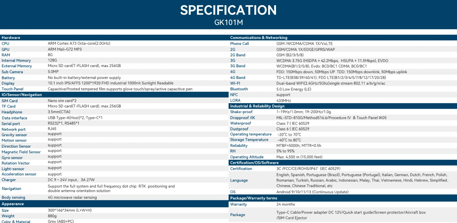
| CPU | ARM Cortex A73 / Octa-core / 2.0GHz |
|---|---|
| GPU | ARM Mali-G72 MP3 |
| RAM / storage | 8GB / 128GB |
| Expandable storage | Micro SD, max 256GB |
| Display | 10.1″ IPS/AFFS / 1200×1920 / 1000 nits |
| Touch panel | Capacitive / frosted tempered film / glove touch, spray, active capacitive pen |
| Front camera | 5.0MP |
| Battery & power | No built-in battery / external power supply |
| External power | DC 9–24V / 3A / 27W |
| Data interface | USB Type-A (Host) ×2 / Type-C ×1 |
| SIM / TF slots | Nano SIM ×2, dual standby |
| Headphone | 3.5mm / CTIA |
| Sensors | Gravity / motion / magnetic field / gyroscope / light / acceleration |
| Body sensing | 4G microwave radar sensor |
| Serial ports | RS232 ×1 / RS485 ×1 |
| Ethernet | RJ45 |
| NFC | Supported |
| LoRa | 433MHz |
| Navigation | Full-constellation, multi-frequency RTK positioning / dual-antenna heading |
| 2G bands | GSM B2 / B3 / B5 / B8 |
| 3G bands | WCDMA B1 / B2 / B5 / B8 |
| 3G data | WCDMA 3.75G / HSDPA+ 42.2Mbps / HSUPA+ 11.5Mbps |
| 4G bands | TD-LTE B38 / B39 / B40 / B41; FDD-LTE B1 / B2 / B3 / B4 / B5 / B7 / B8 / B12 / B17 / B20 / B28 |
| 4G data | FDD / TDD: 150Mbps down / 50Mbps up |
| Wi-Fi | 2.4GHz / 5GHz / 802.11 a/b/g/n/ac |
| Bluetooth | 5.0 / LE |
| Dimensions | 300 × 166 × 34mm |
| Weight | 880g |
| Colour & materials | Grey / ABS + PC |
| Water / dust protection | Waterproof class 7 / dustproof class 6 (IEC 60529) |
| Vibration | 1–19Hz / 1.0mm; 19–200Hz / 1.0g |
| Drop / impact | MIL-STD-810G / Method 516.6 / Procedure IV / touch panel IK05 |
| Operating temperature | -20°C to 70°C |
| Storage temperature | -40°C to 80°C |
| Reliability | MTBF >5000h / MTTR <0.5h |
| Relative humidity | 5%–95% (non-condensing) |
| Operating altitude | 4500m max |
| Certification | 3C / FCC / CE / ROHS / IP67 |
| OS versions & compatibility | Android 9 / 10 / 11 / 13 |
| Device warranty | 24 months |
| CDMA / EVDO bands | BC0 / BC1 |
Work with product and engineering teams to validate software, modules and operating conditions together.
Share mounting dimensions, input voltage, peripheral protocols and the software environment for configuration advice.
Deployment countries, vehicle or equipment type, display visibility, mounting space and protection requirements.
OS compatibility, applications, tag samples, corrections, power and cable validation.
Sample results, exact model, accessories, volume and rollout plan.
Assess GK101M against accuracy targets, receiver configuration, antennas, corrections and output protocols. Distinguish GNSS, RTD and RTK configurations and validate application integration in the field.
For: GIS software providers, surveying teams and positioning integrators
Check model datasheets · Prepare SDK and application interfaces · Discuss your project configuration
Talk to SOTEN about your application, device configuration and system integration.