
Surveying & GIS collection
Capture positions for field features, asset locations and site verification through surveying software and GIS workflows.
H81 RTK High-precision GNSS / RTK Rugged Tablet. Assess H81 RTK against accuracy targets, receiver configuration, antennas, corrections and output protocols. Distinguish GNSS, RTD and RTK configurations and validate application integration in the field.
A high-precision rugged tablet for field data collection, surveying, vehicle dispatch and agricultural-system integration. Connect UM960 RTK, mobile connectivity and industry applications to your location workflows.
Appearance reference; interfaces and accessories depend on the selected configuration.
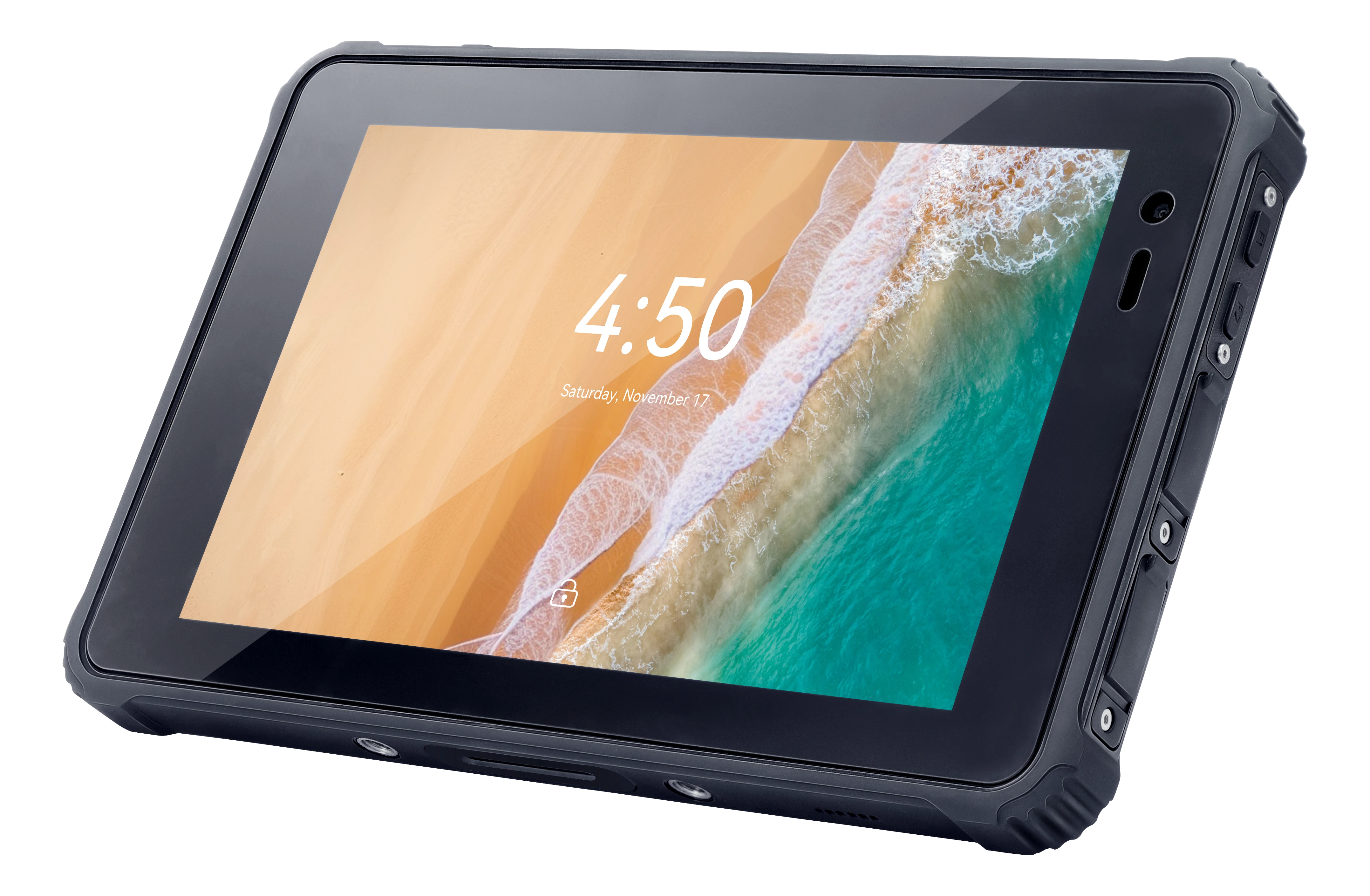 Device appearance reference
 Rear design reference
 Interface location reference
 Hand-strap reference
 Device specifications & interfaces
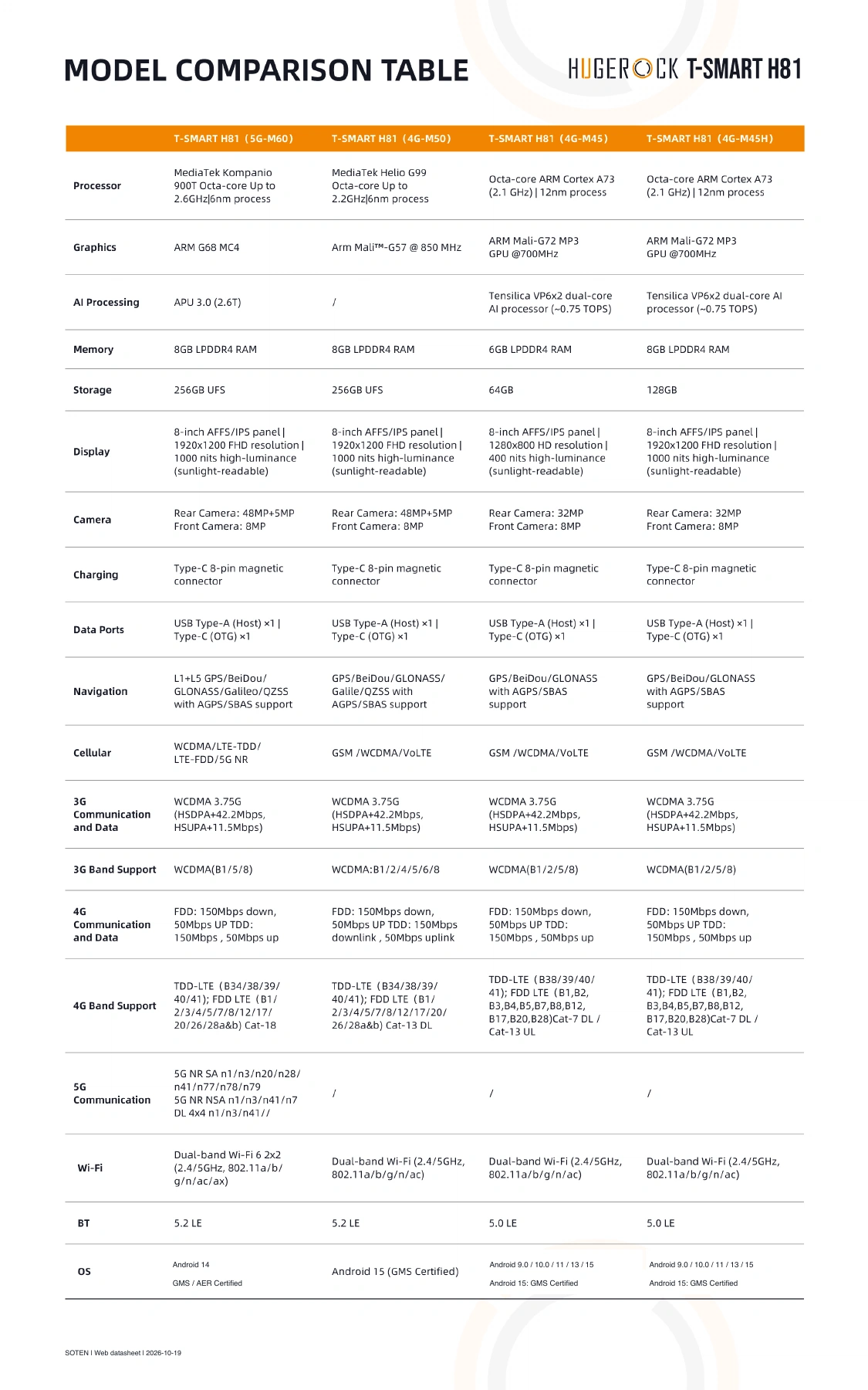 Computing configuration comparison
Product images · configuration varies by model · select an image to enlarge
Capture positions for field features, asset locations and site verification through surveying software and GIS workflows.
Work with fleet-management and integration partners on location reporting, dispatch tasks and mobile applications for construction and site vehicles.
Provide a terminal and positioning-data interface for agricultural work records, machinery location services and autonomous-driving system integration.
Specifications below apply to the H81 RTK / 5G-M60 configuration. Compare other computing options through H81 selection.
| Processor | MediaTek Kompanio 900T · Octa-core · up to 2.6GHz · 6nm |
|---|---|
| Graphics | ARM G68 MC4 |
| AI processing | APU 3.0 (2.6T) |
| Memory | 8GB LPDDR4 RAM |
| Storage | 256GB UFS |
| Expandable memory | microSD, up to 2TB |
| Display | 8-inch AFFS/IPS · 1920x1200 · 1000 nits |
| Rear camera | 48MP + 5MP |
| Front camera | 8MP |
| Battery | 12,000mAh removable battery |
| Data ports | USB Type-A (Host) x1 / Type-C (OTG) x1 |
| Charging | Type-C / 8-pin magnetic connector |
| Cellular | WCDMA / LTE-TDD / LTE-FDD / 5G NR |
| Wireless | Wi-Fi 6 2x2 (2.4/5GHz, 802.11a/b/g/n/ac/ax) / BT 5.2 LE |
| Navigation | L1+L5 GPS/BeiDou/GLONASS/Galileo/QZSS, AGPS/SBAS |
| OS | Android 14 (GMS / AER Certified) |
| Dimensions | 223 x 146 x 23mm (LxWxH) |
| Weight (including hand strap) | 886g |
| Water/dust resistance | IP68 (IEC 60529) |
| Drop / impact | MIL-STD-810H compliant (1.8m) / IK08 |
| Operating temperature | -31°C to 55°C |
| Storage temperature | -40°C to 80°C |
| Humidity | 5% to 95% (95%RH, non-condensing) |
| Altitude | Up to 4,500m (15,000 feet) |
RTK accuracy is the module specification under fixed-solution conditions. Actual performance depends on satellite visibility, antenna, correction services and site conditions. Ask about domestic positioning options through H81 selection.
| Positioning module | UM960 · P/N 02690173 |
|---|---|
| Architecture | NebulasIV GNSS SoC · 1408-channel signal processing |
| Constellations | BeiDou / GPS / GLONASS / Galileo / QZSS / SBAS |
| Single-point positioning (RMS) | Horizontal: 1.5m / Vertical: 2.5m |
| DGPS positioning (RMS) | Horizontal: 0.4m / Vertical: 0.8m |
| RTK fixed solution | Horizontal: 0.8cm + 1ppm / Vertical: 1.5cm + 1ppm |
| Update rate | 10Hz |
| Interface | UART / TTL |
Select the OS version for your application environment, existing business software and regional deployment requirements.
| H81-5G-U62 | Android 13 / OpenHarmony 6.0 / Starlight Kylin |
|---|---|
| H81-5G-M60 | Android 14 (GMS and AER Certified) |
| H81-4G-M45 | Android 9.0 / 10.0 / 11 / 13 / 15; Android 15 GMS certified |
| H81-4G-M45H | Android 9.0 / 10.0 / 11 / 13 / 15; Android 15 GMS certified |
Include your environment, OS, modules, deployment country and expected quantity in your enquiry.
| H81-5G-M60 | 05121172 |
|---|---|
| H81-4G-M50 | 05121174 |
| H81-4G-M45 | 05121175 |
| H81-4G-M45H | 05121176 |
Contact SOTEN for configurations without a listed ordering code.
Design the deployment around antenna placement, correction services, coordinate systems, mounting, power and network coverage. Validate fixed-solution status, accuracy and updates in the field before connecting dispatch or operational systems.
Review configurations, network bands and module performance for technical evaluation and procurement.
Discuss your application, deployment country, software interfaces and purchasing plan with SOTEN for configuration and project support.
Assess H81 RTK against accuracy targets, receiver configuration, antennas, corrections and output protocols. Distinguish GNSS, RTD and RTK configurations and validate application integration in the field.
For: GIS software providers, surveying teams and positioning integrators
Check model datasheets · Prepare SDK and application interfaces · Discuss your project configuration
Talk to SOTEN about your application, device configuration and system integration.